DRAG

Delivering quality construction solutions for modern living and sustainable developments.

Get In Touch

img

No: 1, Kannaki street, 1st Floor, Kottai,

Erode - 638001

Services Details

  • Home
  • Services Details
Boundary Survey

Boundary Survey

Boundary surveys establish exact land extents based on legal records and physical verification to ensure ownership clarity.

  • Boundary identification as per revenue records
  • Legal ownership verification support
  • Peg marking with permanent reference points
  • Essential for registration & documentation
  • Prevention of future boundary disputes
Used for: Land registration, Ownership verification, Fencing & compound walls, Sale & purchase documentation
Layout Marking

Layout Marking

Layout marking converts approved drawings into accurate on-site markings, ensuring proper plot division and road alignment.

  • Internal road centerline & edge marking
  • Plot division and numbering
  • Accurate alignment as per approved plans
  • Compliance with planning authority norms
  • Ready for development execution
Used for: Residential layouts, Commercial developments, DTCP / CMDA approved projects
Boundary Stone Fixing

Boundary Stone Fixing

Boundary stone fixing provides permanent physical demarcation of land limits to avoid encroachment and disputes.

  • Precise placement using survey coordinates
  • Durable boundary stone installation
  • Exact alignment with legal records
  • Long-term boundary protection
  • Verified and documented fixing
Used for: Property demarcation, Fencing works, Agricultural & residential lands
Land Sub Division

Land Sub Division

Land subdivision services divide large land parcels into smaller plots following statutory norms and approval requirements.

  • Subdivision planning as per regulations
  • Accurate land measurement & plot calculation
  • Preparation of approval-ready drawings
  • Compliance with DTCP / CMDA norms
  • Support for registration & approvals
Used for: Plot development, Layout approvals, Sale & registration purposes
Topographical Survey

Topographical Survey

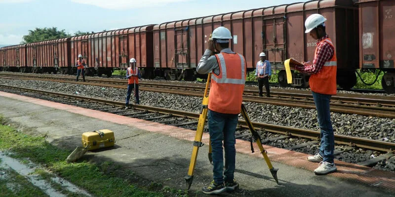
Detailed topographical surveys capturing natural and man-made features, elevations, and ground conditions using advanced surveying instruments.

  • Terrain & surface feature mapping
  • DGPS / GNSS based coordinate fixing
  • Accurate elevation data collection
  • 2D & 3D AutoCAD drawings
  • Planning & feasibility study support
Contour Mapping

Contour Mapping

Contour mapping identifies elevation variations across land for effective drainage, road, and site development planning.

  • Contour generation at required intervals
  • Precise level data measurement
  • Drainage flow & slope analysis
  • Engineering-ready contour drawings
  • Earthwork planning support
Foundation & Column Marking

Foundation & Column Marking

Accurate on-site marking of foundations and columns ensuring structural alignment as per approved drawings.

  • Centerline & gridline marking
  • Exact column position fixing
  • Dimensional accuracy verification
  • Stage-wise construction checks
  • Error-free structural execution
PEB Bed Bolt Marking

PEB Structure Bed Bolt Marking

High-precision bed bolt marking for PEB structures ensuring proper alignment and load transfer.

  • Exact bolt center marking
  • PEB drawing-based execution
  • Millimeter-level accuracy
  • Supports smooth steel erection
  • Prevents alignment failures
Road Survey

Road Survey

Engineering road surveys for alignment design, profiling, and infrastructure development.

  • Horizontal & vertical alignment fixing
  • Longitudinal & cross-section surveys
  • Carriageway & shoulder measurement
  • Chainage & offset marking
  • IRC standards compliance
Pipeline & Canal Survey

Pipeline & Canal Survey

Linear surveys for pipelines and canals ensuring proper slope, alignment, and flow efficiency.

  • Pipeline & canal alignment survey
  • Gradient & slope fixing
  • Profile & section drawings
  • Chainage reference marking
  • Accurate level control
As-Built Survey

As-Built Survey

As-built surveys record actual constructed positions for verification, documentation, and approvals.

  • Verification with approved drawings
  • Actual construction measurements
  • Final record drawings
  • Completion documentation
  • Authority approval support
Earthwork Calculation

Earthwork Volume Calculation (Cut & Fill)

Accurate earthwork quantity calculations for cost estimation and site planning.

  • Cut & fill volume computation
  • Pre & post-level comparison
  • Contour-based quantity analysis
  • BOQ-ready quantity reports
  • Cost & resource optimization

Need Help? Call Here

+91 98949 66433 Get a Quote